
Under-Keel Clearance (UKC) is the vital vertical distance between a ship’s lowest hull point (keel) and the seabed, ensuring enough water to prevent grounding. UKC is calculated by subtracting the ship’s draft from the available water depth as well as factoring in dynamic effects like tides, and waves for safe passage, especially in shallow waters.
Insufficient UKC risks grounding, which can cause vessel damage, cargo loss, and danger to crew. Mariners must calculate UKC carefully before entering shallow waters or crossing bars.
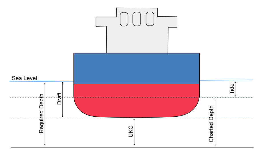
Requirement Definitions
- Required Depth – Depth between Sea Level and Sea Bed
- Draft – Height of Hull below water line
- UKC – Clearance between bottom of keel and seabed
- Charted Depth – Depth of water at LAT.
- Tide – Tidal Height above LAT
UKC Example Calculations
Following is the formula for calculating required height of tide:
- Required UKC + Vessel Draft = Required depth of water
- Required depth of water – Charted Depth = Required Height of Tide
In this example, a vessel with a draft of 2.5 metres requires safe under-keel clearance of 1.5 metres over the sand bar marked on the chart as 3 metres at LAT. What tide is required to safely pass into the inlet?
UKC Required |
1.5m |
Vessel Draft |
2.5m |
Required Depth of water (Draft + UKC) |
4m |
Charted Depth |
3m |
Required Height of Tide (Required – Charted) |
1m |
To calculate at what time it is safe to pass over the bar, you will again need to use the Standard Tide Curves finding the required depth
Using an example, lets say that we estimate to arrive outside the Brisbane Bar at 17:00 and need to work out when we can safely pass over. We know we require a 1m tide to have a minimum required depth of 4m. We now need to find the tide in the tides table, calculate tide range and plot on the Tidal Curve to find the time difference to high water.
Following is an example extract of Tide Levels from the 2025 Queensland Tide Tables on 16th of April 2025 for Brisbane Bar:
Description |
Time |
Metres from (LAT) |
|---|---|---|
Low Water (LW) |
05:32 |
0.73m |
High Water (HW) |
11:04 |
1.88m |
Low Water (LW) |
17:12 |
0.56m |
High Water (HW) |
23:41 |
2.33m |
High Water |
2.33m |
Low Water |
0.56m |
Tidal Range |
1.77m |
Having calculated tidal range, we can plot the height on the Tidal Curve to find time where we have required depth. Please note that the projected tidal range (Green line) is a line that is offset from the nearest existing range curve (Black curve lines):
- Find Height: Required Height – Low Water = 1m – 0.56m = 0.44m
- Plot a horizontal line from 0.44m on the left vertical axis of the Tidal Chart (blue line) through intersection projected 1.77m tidal range (green Line on tidal chart)
- Plot a vertical line intersection horizontal line (red line) from projected 1.77m tidal range and intersected horizontal line
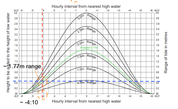
- The plotted hourly interval as read of the x-axis is: 4:10
- Required depth will be at: High Water Time – Tidal Curve Interval = 23:41 – 4:10 = 19:31
At 19:31, the tide height is approximately 1 meter above the Lowest Astronomical Tide (LAT) and safe to pass over the bar.